Naming roads by the town they are headed to is also done in the USA, but not with highways. Lyme road (in Hanover, New Hampshire) is indeed the road to Lyme and the same road is called 'Hanover Rd' when you are in Lyme. Somewhere in the middle they meet and become one. The convention works for the most part, though there is also a "North Thetford Road" in Lyme which does not go to North Thetford, but ends at River Road, along the bank of the Connecticut, where there was once a bridge to North Thetford, though it was destroyed about a century ago. They could have perhaps renamed the road to 'River Road" in order to indicate its new post flood destination, except there already is a River Road, running along the river. Indeed North Thetford Road now ends at River Road, so maybe it could be called the "River Road Road", indicating it is the road that leads to river road?
Lyme is an old town though. In modern developments in the US, roads are purposely built to avoid going anywhere, thereby keeping traffic slow in the McMansion developments full of little lord Fauntleroy's who might, horrors, chase a soccer ball into a street now and then. In these places the roads are all named after some category of nouns like trees or presidents, or flightless ground birds. Directions to someone's house generally sound like: "just stay on Quail Lane until you see Ptarmigan Street, take a right. The third crossing will be Guinea Fowl Avenue, turn left, and from there just keep straight until you see Dodo Drive on the right - we're in the cul-de-sac at the end".
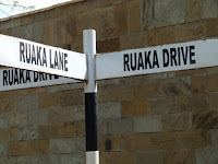
In Kenya some roads are named after their destinations. Like Limuru road - which is the road we take from our home in Runda out to Lake Naivasha via, surprise, Limuru. But there is another naming convention where in some area, such as in Runda and neighboring Ruaka, the roads are all simply called by the area name and then distinguished by changing the word for 'road'. Like trying to relabel the US suburb using only one flightless bird name (hmmm...take Quail Lane, right on Quail Drive, left on Quail Road, and then to the end of Quail Close). Let me provide an example. Min and I walked Apple today starting at our house on Runda Drive, to Ruaka Drive, Past Ruaka Lane, to Ruaka Road, then Runda Road, past Runda Ridge, down Ruaka Grove, past Ruaka Annex, back onto Runda Road, and finally home again on good old Runda Drive. Get the picture? (incase not I have attached them). And this is actually a fairly simple walk since we didn't have the energy to walk all the way over to Runda or Ruaka Close, Crescent or Gardens. As you can see the first word indicates nothing beyond the general vicinity one is in, then the imaginative Kenyan town 'planners' swap out all possible synonyms for 'road' in order to drill down to the streetview level. Someone in town probably has a really big thesaurus. This is particularly confusing for people like me with mild dyslexia since, unless I concentrate, which I rarely do while walking the dog, I usually don't make out the difference between 'Ruaka' and 'Runda' anyway since they both start with 'Ru' and end in 'a' and are about the same length. Even the locals get confused - as for example happened to whoever was in charge of putting in the house number signs and located 196 Ruaka Road directly adjacent to 197 Runda Drive. Which is it? (for the record, Ruaka Road).
Our next destination is Japan. I understand from Wikipedia (cited below) they employ something that at first sounds a bit similar to Kenya, or Paris with its clockwise number arrondissements, whereby it is regions rather than directions that matter, and - here is the real kicker - the numbers are ordered in time rather than space, so that buildings built earlier have the low numbers and modern ones the high numbers. Sounds like we are in for some really interesting dog walks.
Wikipedia Quote: The Japanese addressing system is based on areas, subdivided from big to small. The largest division is called a "Prefecture" in English. There are 47 prefectures in Japan. A prefecture can be one of four things in Japanese, To (都), capital, for Tokyo only, Dō (道), territory, for Hokkaido only, Fu (府), metropolis, for Osaka and Kyoto, and 43 Ken (県), which cover the rest of the country. The Ken are divided into counties, Gun (郡), or cities, Shi (市). Small cities are generally divided into Chō (町). This is translated as "town" or "village" in the dictionary, but corresponds to "areas" or "neighbourhoods". Big cities are divided into Ku (区), "wards".
Wards are divided into Chō (町), though sometimes the name doesn't include the word Chō. Sometimes the Chō are divided into Chōme (丁目), which are numbered divisions of a Chō. Then the blocks are numbered and, at the lowest level, the building has a number. Finally comes the room or apartment number. For an apartment, the name of the apartment building is often included. However, it is not necessary for mail. It is, however, a convenience for visitors who ask for directions. The buildings within a block are either numbered in the order that they were built, so they jump all around, or numbered in clockwise order around the block. In this clockwise numbering there is sometimes skipping of several numbers for later assignment, where future construction between existing buildings is possible.


